
Maria Consiglia Rasulo
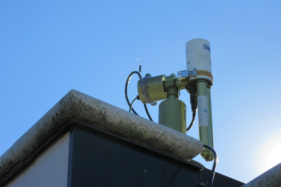
A photometer of the 'AERONET' network, positioned at the Archaeological site of Grotte di Catullo in Sirmione on Lake Garda, was inaugurated last October 22.
The sun photometer Cimel is a tool that helps to measure the values of the optical thickness of the atmosphere and, therefore, it can be an interesting device to evaluate some characteristics of the suspended particles in the atmosphere, such as their quantity and origin, namely if they are desert dust, sea spray, combustion products, etc. The measurements are repeated every 15 minutes during the day, in eight different wavelengths. The collected data are automatically sent to the network AERONET, the international network founded by NASA and PHOTONS, that collects data from similar sensors placed around the world (currently over 400 are active).
"The Sirmione photometer was positioned at a strategic point on the northern tip of the Sirmione peninsula," says Claudia Giardino, IREA researcher and Principal Investigator of the network site. "This will allow us to collect data from a visual horizon wide enough. Its contribution to the monitoring of the atmosphere will add to that valuable of other similar photometers positioned in the Po Valley, Venice, Modena and Ispra long ago."
The measurements on the ground of the Cimel photometer can also be very useful for the treatment of data derived from satellite measurements of the area, allowing us 'to correct' the satellite images, 'disturbed' by the atmosphere and the powders present in it. In short, the photometer will allow us 'to read' and better interpret the satellite images of the Gardesana areas with a better assessment of the ecological parameters of these environments. The instrumentation purchase and placement have been possible thanks to the funding from the Lombardia Region within the SINOPIAE Project and the collaboration with the Superintendence for Archaeological Heritage of Lombardia that granted its installation on the roof of the Sirmione Museum located in this archaeological area.
As part of the activities that the European Commission plays in monitoring the potential effects of electromagnetic fields on health, IREA participates in the activities of SCENIHR (Scientific Committee on Emerging and Newly Identified Health Risks).
The researchers Maria Rosaria Scarfì and Olga Zeni, named "external experts" by the Commission, have contributed to the drafting of the “Opinion on Potential Health Effects of Exposure to Electromagnetic Fields (EMF)", published March 6, 2015.
Primary purpose of the "Opinion" is to update the previous report of 2009 through the review of the scientific literature on the effects of non-ionizing electromagnetic fields published in the period 2009-2014. In addition, the new publication covers areas for which, in the past, major "gaps in knowledge" had been identified, and discusses the possible mechanisms of interaction between electromagnetic fields and biological systems and the potential role of co-exposures to environmental stressors.
Read the SCENIHR opinion on potential health effects of electromagnetic fields ![]()
Read a summary of the Opinion in this easy to read fact sheet ![]()
The fourth International Space Apps Challenge will take place all around the world on April 11 and 12, 2015. This is the largest worldwide Hackathon with thousands of participants in all continents who collaborate and work together over 48-hours to design innovative solutions for the most thrilling challenges that world is facing today. NASA is leading this global collaboration along with a number of government collaborators and over 100 local organizing teams across the globe.
IREA is one of the local organizers of this mega event, along with the Department of Industrial Engineering, University of Naples Federico II, in collaboration with the U.S. Consulate Southern Italy. Dr. Chandrakanta Ojha, a Research Fellow at IREA, along with other scientists of IREA have taken the initiative for organizing the Space Apps Challenge 2015 in Napoli.
For more details and/or to partecipate in the event click on the link https://2015.spaceappschallenge.org/location/napoli/.
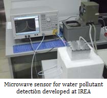 The measurements of the dielectric properties of materials are subject of numerous studies due to their implications in various application fields. The ability to monitor non-destructively and in real-time the response of materials to electromagnetic fields at microwave and terahertz frequencies provides useful information about various physical and chemical parameters of the material under test. For a specific orientation of the electric field and a fixed working frequency, the electromagnetic properties of a substance can be related to physical parameters such as temperature, concentration, pressure, humidity, mechanical stress, molecular structure, and so on. Therefore, such sensors are of interest in many application contexts, including:
- Food industry and agriculture: estimation of heating rates when the materials are exposed to high intensity fields, determination of moisture content, food storage, verification of product quality, etc.;
- Medical and pharmaceutical industry: tissue characterization, testing and production of drugs, characterization of solvents, chemical reactions, etc.;
- Electronics industry: characterization of substrates, printed circuit boards, etc.;
- Aerospace/defense industry: radar absorbent materials, radomes, etc.
In this framework, the activities carried out by researchers of IREA are devoted to the design and characterization of microwave sensors (e.g. sensors for the characterization of liquid solutions and bioradar sensors), and to investigations at THz frequencies in order to carry out a quantitative characterization of materials by exploiting their unique spectral response in this band.
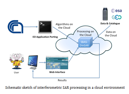
The Differential SAR Interferometry (DInSAR) is a well-established microwave remote sensing technique that allows us to estimate the ground deformations with centimeter to millimeter accuracy. In the last decades, thanks to both the ever increasing SAR data availability as well as the development of advanced algorithms, such as the Small BAseline Subset (SBAS) technique, differential interferometry has shown to be a very effective tool not only to better comprehend geophysical phenomena at local and regional scales, but also to support natural and anthropogenic hazard mitigation and management.
The current DInSAR scenario is characterized by the huge availability of SAR data acquired firstly by the ESA ERS and ENVISAT sensors, then by the RADARSAT-1/2 Canadian missions and finally by the COSMO-SkyMed (ASI) and TerraSAR-X (DLR) constellations. Moreover, a massive and ever increasing data flow will be further supplied by the recently launched (April 2014) SENTINEL-1A SAR satellite, thanks to its global coverage acquisition policy. This sensor will also be paired during 2016 with the SENTINEL-1B twin system which will allow achieving a system revisit time of 6 days.
In order to fully benefit from such a huge SAR data amount to analyze and monitor Earth's surface deformation, both high performance computing (HPC) resources as well as proper DInSAR algorithms, that are able to effectively and efficiently exploit these computing facilities, are needed.
In this context, the IREA research activity is focused on studying, developing and implementing novel DInSAR algorithmic solutions for the exploitation of high performance computing platforms. Particular attention is given to the use of multi-nodes and multi-cores distributed computing architectures, such as GRID and Cloud, in the perspective of both maximizing the size of employed data-sets and minimizing the processing elapsed times.
Consequently, the main research activity objective is the development of advanced DInSAR methodologies allowing us to handle and process the increasing available SAR data amount within reasonable time frames. Furthermore, the implementation of innovative algorithmic tools for the generation of Earth's surface displacement maps at continental scale, which can be used for a global analysis and therefore a comprehensive understanding of ground deformation phenomena, is under investigation. The achievement of such targets, besides the considerable inherent scientific implications, has important consequences in the Civil Protection framework for natural and anthropogenic hazards management, prevention and mitigation, both in pre-alert and emergency phases.
Finally, the opportunity given by Cloud computing platforms to store data archives, computing resources and processing algorithms, together with the capability to simply share data and results within the research community, open new challenging scenarios for a global scientific knowledge fruition and spread.
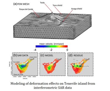
The geophysical processes that take place in several kilometers below the earth's surface, such as the movement of a seismogenic fault, the accumulation of magma, the variation of pressure in the reservoirs magmatic, in many cases cause deformation of the earth's surface that can be measured with geodetic methods and remote sensing techniques such as SAR interferometry (InSAR). The results of these measurements and the subsequent geophysical modeling of the sources, due to the deformation, can provide crucial information for the assessment of volcanic and seismic risk and the proper planning of human activities.
It is possible to model the deforming sources through analytical and numerical approaches. In analytical modeling, the most common models can reproduce the observed deformation in a sufficiently realistic way by using simple functions characterized by a limited number of parameters. Although in these simplified approaches are neglected several aspects (the properties of magma inside the source, including its compressibility, the asperities along the fault plane, the crustal heterogeneity), the analytical models are still a valuable tool for a preliminary evaluation on the localization and the geometric characteristics of the sources that have generated the observed deformation, information obtained through the inversion of surface deformation data (InSAR, GPS, EDM, tiltmetric, etc ...).
Numerical modeling is a powerful tool that can allow realistic simulations of geophysical processes, using heterogeneous information and efficient mathematical methods. There are various numerical modeling techniques; the most used in the Earth Sciences is the FEM (Finite Element Method) technique. The exponential increase in knowledge of geophysical systems and technological development of numerical modeling tools have enabled the implementation of more and more complex modeling approaches, able to represent the spatio-temporal variability of the physical parameters that influence the development of a natural system. In this context, the finite element modeling multi-physics is a new frontier for the understanding the spatial and temporal evolution of different geodynamic settings such as volcanic and seismic areas and those with a hydrogeological instability.
IREA is committed to the development of research activities on the geophysical modeling of remote sensing data; these activities have already provided important results in the study of the major earthquakes that have hit our country in recent years. Relevant are also the results of the analysis of the main Italian volcanoes and various other volcanic sites of great scientific interest.
Francescopaolo Sica, scholarship holder at IREA, was awarded the Best Student Paper Award of SPIE Remote Sensing Conference (Amsterdam, 22-25 Sept. 2014) in the area "SAR Image Analysis, Modeling, and Techniques". The paper "Benefits of blind speckle decorrelation for InSAR processing", by F. Sica, L. Alparone, F. Argenti, G. Fornaro, A. Lapini, D. Reale, is the result of the collaboration between IREA and the Department of Information Engineering of the University of Florence.
The work deals with the problem of limiting the effects of noise from highly reflective targets, typical of the signals acquired from high resolution sensors in X-band as those of the COSMO SKYMED constellation, for the generation of accurate products of SAR interferometry. The latter is a technique that has important implications for the generation of digital elevation maps at a global scale and in the monitoring of deformations associated with natural hazards and security of buildings and infrastructures.
 IREA was present at the ninth edition of the Science Festival in Genoa with a conference entitled "The Earth under control. New technologies for environmental monitoring". Eugenio Sansosti and Ilaria Catapano told as earthquakes, landslides, volcanic eruptions or even imperceptible deformations of the Earth's surface can be monitored from space with a sophisticated radar mounted on satellites. And now it is also possible to follow the evolution of deformations using a technique developed at IREA-CNR, with obvious implications for the prevention of risk and decision support in times of crisis.
The in-situ monitoring is instead made possible by the ground penetrating radar technology. In this context, the methodologies developed at IREA-CNR allow to obtain high-resolution images with which to test the structural integrity of buildings or infrastructures, to identify hidden or buried objects such as weapons and explosives, and to detect remote vital signs essential to locate victims of landslides or avalanches. Sophisticated technologies useful to keep under control the Earth and the complex dynamic system consisting of the earth's crust, in order to live more secure.
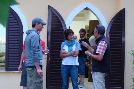
On February 19, 2012 the Experimental Station of the National Research Council "Eugenio Zilioli" in Sirmione celebrates 12 years. Its history relives in the memories of the CNR researchers who alternated in its spaces. In its seat of Punta Staffalo on Lake Garda were carried out many scientific activities, events of outreach and environmental education that have allowed a wide audience to know the scientific contribution of the CNR for the monitoring of waters of the largest lake in Italy.
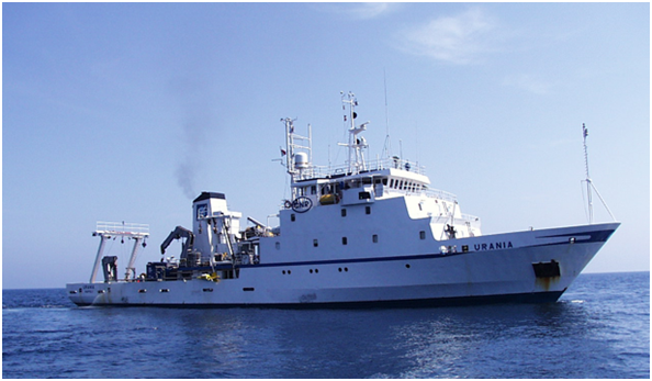 From May 3 to 17, 2012 three research institutes of CNR, IREA, ISMAR and ISSIA will share the CNR research vessel Urania to achieve some measurement campaigns in the Adriatic Sea. This is just one of more than 300 expeditions that Urania has been performing for 20 years of scientific work in the Italian seas and in the Mediterranean, but for the first time there will be the opportunity to follow some aspects of the campaign via the web. For some days researchers will experience a special logbook which will document real-time the expedition stages and the activities carried out during the mission. By connecting to the online platform https://uraniaexpedition.crowdmap.com, it will be possible to read the notes on board, consult the dynamic map, leave comments and send messages.
Tag Cloud
Research activity in evidence
-
Electric, magnetic and electromagnetic field levels monitoring in urban and working environment
The widespread, nationwide diffusion of sources of low (high voltage…