 |
| Paola Carrara | |
| Paola | |
| Carrara | |
| ... | |
| +39 02 23699 295 | |
| Senior Researcher |
Activity
Paola Carrara is a researcher of the Italian National Research Council (CNR), active in the Institute for the Electromagnetic Sensing of the Environment (IREA), unit of Milan. Since December, 2015 she is Responsible of CNR IREA Unit of Milan. Her scientific activity regards designing and managing information systems. Her main interests are in (Fuzzy) Information Retrieval, spatio-temporal archives of images, architectures, technologies and standards for geographic information on the Internet, in particular Web geoservices and Spatial Data Infrastructures (SDI). She is now active also in the field of Citizen Science and Volunteer Geographic Information (VGI).
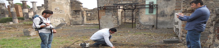
In the years 2006-2008 she was responsible of the Italian branch of the project IDE-Univers which created the first European Spatial Data Infrastructure in the research field. In the years 2009-2010 she represented Regione Lombardia in the scientific activities of the EO/GMES Working Group of NEREUS, the network of European Regions dealing with space. She has been coordinator of the FP7/Space Project DORIS_Net (2011-2013), aimed at developing a European Platform of Regional Contact Offices (RCO) to foster the creation of GMES/Copernicus downstream services, and responsible for the activities of the Lombardy RCO. DORIS_Net created a report on the segmentation of the needs of regional users with respect to products in Earth Observation and established a Copernicus service downstream observatory able to foster contacts between RCOs, users and service providers. The Downstream observatory continuously observes and surveys the Copernicus portfolio on the one hand and iteratively cross checks it with the user needs on the other hand. An added value is created by cross checking these observations and validating them with an interregional view to identify commonalities. She has been advisor for the IT issues in the LIFE+ Project EnvEurope (2010-2013), which creates ecological indicators to the SEIS Programme based on the observations collected in the long-term stations of EU-LTER network. She coordinated the organization of “Pink … blue… green! Eco-relay trail through LTER sites from Monte Rosa to Lake Maggiore”, a popular science event in the CNR initiatives for EXPO 2015 (http://www.lteritalia.it/it/cammini/rosa). She participated in the Lombardy Regional Project “Space4Agri: Sviluppo di Metodologie Aerospaziali Innovative di Osservazione della Terra a Supporto del Settore Agricolo in Lombardia” (20013-2015) (http://space4agri.irea.cnr.it/it). Space4Agri aims at integrating information from the space-aircrafts and in situ stations, and to involve citizens in the collection of data and dissemination of the results; in this project she has been leader in the analysis to identify target users and define their requisites. She is now coordinator of the SubProject 7 (SP7) of RITMARE, flagship project of the Italian Ministry of University and Research, the leading national marine research project for the period 2012-2016; the goal of SP7 is to create the interoperable infrastructure for the observation network and marine data of RITMARE (http://www.ritmare.it/sp7). In RITMARE SP7 she coordinates a R&D group that designed and developed GET-IT Starter Kit (www.get-it.it), an open source and free software suite allowing researchers to easily share maps, measurements, and sensors, by creating autonomous data distribution standard web services. Within the network LTER-Italy and RITMARE she is particularly engaged in researches on Citizen Science and Volunteer Geographic Information, looking at methods and technologies to integrate heterogeneous information sources collected from multiple, mobile devices.
Participation in international projects:
Recent teaching and organization activities :
She published papers in international and national Journals, in books and at Conferences in the topics of her research. |
Curriculum

Scientific production
Presentations
More info
Tag Cloud
Research activity in evidence
-
Mircowave and terahertz sensors
The measurements of the dielectric properties of materials are subject…