Interoperable infrastructures for geodata

geoviewerAlso the realm of Geographic Information Systems (GIS) faced a process of 'webbing'. Internet is now a widespread development platform for geodata, whose usage is mainly performed online. It favours the creation of vendor-independent, modular applications, based on standards and interoperability principles.

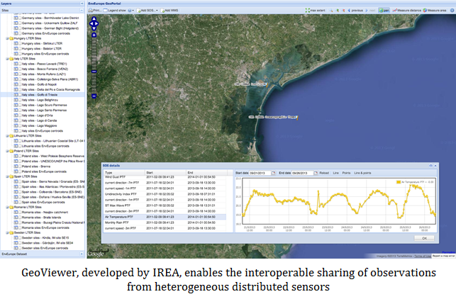
IREA researches in this field were born from the need of using the Web to spread and process geospatial products of the research, mainly maps from Earth Observation as well as in-situ observations. Keywords are: interoperability of data and systems, independence of delivery tools with respect to accessing and viewing clients, storage and maintenance of data where they are produced.

All activities are framed within outstanding international initiatives, such as the European Directive INSPIRE, the Copernicus Programme of the European Commission, GEO-GEOSS, SWE and the GRID platforms.


Additional Info

IREA research activities that host and distribute their data by the deployment of web services cover different applications.  In particular are focussed on:

  • Water resources: thematic maps and observation related to water quality  of inland waters, lake biodiversity and snow/ice covers. Geo-data have associated metadata, which can be searched by a catalogue service. Data distribution and access is deployed by OGC standard services: WMS, WFS, WCS e SOS
  • Fires: thematic maps of burned areas in Italian Natural Reserves throughout many years 

For an overvieew on geo-data and services provided by IREA refer to the paper: L. Criscuolo, M. Pepe, S. Lella, P. Carrara, OGC Web Services in the workflow of a research Institute dealing with Remote Sensing data, International Conference on Data flow: from Space to Earth, Venezia (Italy), 21-23 March 2011, Flash memory Proceedings, paper number 10127 

The reasearches and applications make use of methods and technologies belonging to the following sectors: 

Spatial Data Infrastructures and Web Geo-Services for the INSPIRE Directive

Web Services for the Sensor Web

Volunteered Geographic Information

GRID computing

This research activity of high technological content is highly oriented to applications; it produces not only technological and scientific papers (see the reference for participants) but also actual implementations, which include geoservices deployed and offered by IREA (see research products), some clients to access and visualize data/services or some parts of them (again see esearch products) and, above all, create an expert knowledge able to create research network, collaborations and opportunities to share projects with other research centres and pubblic administrations, both national and international. The experties and knowledge have an high trasferability, especially to companies dealing with geographic information systems. 

Papers regarding this activity could be retrieved from CVs of researchers collaborating to it.  Further products of this activity are geoportals thata are designed on the interoperability and web services concepts. They can be found at the following URLs:

  • demo geoportal: http://ows.ise.cnr.it/demo/map.phtml

  • Lake Garda geoportal : http://geoportalegarda.irea.cnr.it:8081/Portale_Garda/index.html

  • IDE-Univers Project geoportal: http://www.ideunivers.eu/gestor/ideunivers/index.php

  • Moreover some web geo-services, which share geographic data and metadata of the Institute, can be accessed following the OGC standards :

    Type of Service  Contents End point for access
    OGC CS-W Metadata catalogue http://.....
    OGC WMS Web Map Service http://.....

    IREA experties in the field have been achieved by carring on several projects, mainly international ones. Here we refer to some projects:

    In the European FP7 Project AWARE it has been developed a spatial data infrastructure following the European Directive INSPIRE and estimates of run-off, as ruled by snow melt, were obtained by chaining different OGC web services (CS-W, WMS, WFS, WPS) each implementing the different processing steps of an hydrological model, assimilating snow cover information, as derived from satellite remote sensing.

    The IREA SDI has been established at first during the European INTERREG project IDE-Univers, coordinated by the Catalan Regional Government. In this Project IREA has coordinated the Italian partnership as composed by research centres and university, for the creation of a standard catalogue service (OGC CS-W) of available metadata (around 1100) and of a network of some geo-serices (mainly WMS)

    As concerns the deployment of geodata over the Web IREA is also involved in:

    • European Project LIFE+ EnvEurope (Environmental quality and pressures assessment across Europe)
    • National project within CNR GIIDA (Gestione Integrata e Interoperativa dei Dati Ambientali)
    Ministero Ambiente – Repertorio Nazionale
    Regione Lombardia, Infrastruttura cartografica
    CNR-ISMAR
    CNR-ISE
    CNR-IMAA
    52°North, Initiative for Geospatial Open Source Software GmbH Munster, Germania