
The Differential SAR Interferometry (DInSAR) is a well-established microwave remote sensing technique that allows us to estimate the ground deformations with centimeter to millimeter accuracy. In the last decades, thanks to both the ever increasing SAR data availability as well as the development of advanced algorithms, such as the Small BAseline Subset (SBAS) technique, differential interferometry has shown to be a very effective tool not only to better comprehend geophysical phenomena at local and regional scales, but also to support natural and anthropogenic hazard mitigation and management.
The current DInSAR scenario is characterized by the huge availability of SAR data acquired firstly by the ESA ERS and ENVISAT sensors, then by the RADARSAT-1/2 Canadian missions and finally by the COSMO-SkyMed (ASI) and TerraSAR-X (DLR) constellations. Moreover, a massive and ever increasing data flow will be further supplied by the recently launched (April 2014) SENTINEL-1A SAR satellite, thanks to its global coverage acquisition policy. This sensor will also be paired during 2016 with the SENTINEL-1B twin system which will allow achieving a system revisit time of 6 days.
In order to fully benefit from such a huge SAR data amount to analyze and monitor Earth's surface deformation, both high performance computing (HPC) resources as well as proper DInSAR algorithms, that are able to effectively and efficiently exploit these computing facilities, are needed.
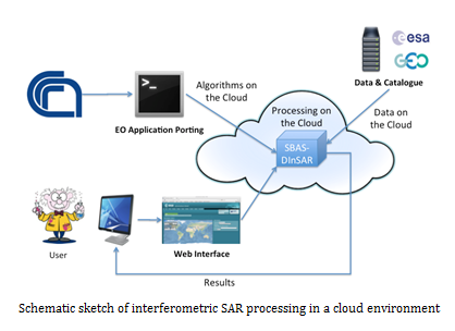
In this context, the IREA research activity is focused on studying, developing and implementing novel DInSAR algorithmic solutions for the exploitation of high performance computing platforms. Particular attention is given to the use of multi-nodes and multi-cores distributed computing architectures, such as GRID and Cloud, in the perspective of both maximizing the size of employed data-sets and minimizing the processing elapsed times.
Consequently, the main research activity objective is the development of advanced DInSAR methodologies allowing us to handle and process the increasing available SAR data amount within reasonable time frames. Furthermore, the implementation of innovative algorithmic tools for the generation of Earth's surface displacement maps at continental scale, which can be used for a global analysis and therefore a comprehensive understanding of ground deformation phenomena, is under investigation. The achievement of such targets, besides the considerable inherent scientific implications, has important consequences in the Civil Protection framework for natural and anthropogenic hazards management, prevention and mitigation, both in pre-alert and emergency phases.
Finally, the opportunity given by Cloud computing platforms to store data archives, computing resources and processing algorithms, together with the capability to simply share data and results within the research community, open new challenging scenarios for a global scientific knowledge fruition and spread.