
Researchers at the Institute for Electromagnetic Sensing of the Environment (IREA) have obtained a drastic improvement in mapping surface deformations thanks to data acquired by the year-old European satellite Sentinel-1A. The result, which opens new perspectives for earthquake and volcano monitoring, has been recently reported on the European Space Agency website.
"Our study - said Riccardo Lanari, Director of IREA - clearly demonstrates that we can dramatically increase the spatial coverage of deformation maps, in terms of pixel density, in comparison to the results obtained with previous generations of SAR systems such as ERS and Envisat."
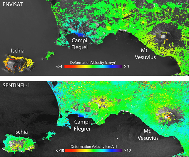
This is evident when comparing the mean deformation velocity maps generated from Sentinel-1A and Envisat data over Napoli Bay (Italy), where three main volcanic complexes – Mount Vesuvius, Campi Flegrei Caldera and Ischia island – are located. In particular, the Sentinel-1A maps clearly show the volcano’s ‘spreading effect’ at the summit of Mount Vesuvius, which was only partially visible with previous products from ERS and Envisat. Also evident is the improvement of the measurement density achieved over the Campi Flegrei Caldera, characterized by an ongoing uplift.
The result has been achieved thanks to the SBAS (Small BAseline Subset) technique developed by IREA researchers, which permits the generation of spatially dense and highly accurate mean deformation velocity maps.
Already worldwide used, this technique is getting a growing interest. This is evidenced, for instance, by the large use of a version of the SBAS technique implemented in the Grid Processing On Demand (GPOD) portal of the ESA Geohazards Exploitation Platform (GEP), which allows users to perform automatic and user-friendly advanced analysis of the Earth's surface deformations by using ERS and Envisat data, and, in a near future, also Sentinel-1 data.
“The possibility to access Sentinel-1 SAR data, with the large coverage and a free and open access data policy, opens new perspectives in civil protection scenarios,” noted Michele Manunta, a researcher of IREA. “For instance, we may already generate, in an operational context, interferograms of nearly the entire Italian territory.”
Surface deformation mapping will be further improved with the upcoming launch of Sentinel-1A’s sister satellite – Sentinel-1B – that will shorten the revisit time from 12 to six days.