Immediately after the Ischia earthquake of 21 August 2017, researchers at CNR-IREA measured the Earth surface displacements thanks to the data acquired by the European Sentinel-1 and Italian COSMO-SkyMed constellations of satellites. A subsidence up to 4 centimetres was measured close to Casamicciola Terme.
During the post-event phase, the Department of Civil Protection (DPC) activated the National Research Council - Institute for the Electromagnetic Sensing of the Environment (CNR-IREA) of Naples, as Centre of Competence in the radar data processing, to analyse and measure the Earth surface displacements induced by the earthquake.
By exploiting the radar data acquired by the European Sentinel-1 satellites of the Copernicus programme, as well as those of the Italian COSMO-SkyMed (CSK) constellation - owned by the Italian Space Agency (ASI), Centre of Competence for the acquisition and use of satellite data, and the Italian Ministry of Defence - a team of researchers at CNR-IREA measured the earthquake-induced ground displacements by exploiting the Differential SAR Interferometry (DInSAR) technique. Such a technique allows measuring, by using radar images acquired before and after an event, the ground displacement along the sensor Line of Sight (LOS) occurred in the interval between the two acquisitions with centimetre accuracy. Moreover, thanks to the satellite ascending and descending passes it is possible to compute the Vertical component of the deformation field.
Table 1 lists the interferometric pairs shown in the following Figure 1; note that the list of Table 1 represents only a portion of the interferograms effectively generated by CNR-IREA
Table 1: Co-seismic interferometric pairs relevant to the Ischia earthquake
|
Sensor |
Interometric Pair |
Wavelength [cm] |
Perpendicular Baseline [m] |
Orbit Pass |
|
S1 |
16082017 – 22082017 |
5.5 |
7 |
DISC |
|
S1 |
16082017 – 22082017 |
5.5 |
55 |
ASC |
|
S1 |
17082017 – 23082017 |
5.5 |
108 |
ASC |
|
CSK |
19082017 – 23082017 |
3.1 |
67 |
DISC |
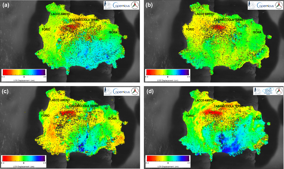
Figure 1 shows the co-seismic displacement maps in LOS obtained from the S1 and CSK data pairs reported in Table 1 and computed in correspondence to the pixels characterized by a high quality of the interferometric signal (the so called coherent pixels). Although several atmospheric artefacts are clearly present, it is evident a region of increased range change (represented in red) around 1 km South-West of Casamicciola Terme.
Figure 1 – Displacement maps (in LOS) obtained from Sentinel-1 (S1) and COSMO-SkyMed (CSK) SAR data: (a) map relevant to the 16082017– 22082017 S1 ascending pair; (b) map relevant to the 16082017–22082017 S1 descending pair; (c) map relevant to the 17082017– 23082017 S1 ascending pair; (d) map relevant to the 19082017– 23082017 CSK ascending pair. Contains modified Copernicus data (© 2017). CSK data are copyright of ASI (2017).
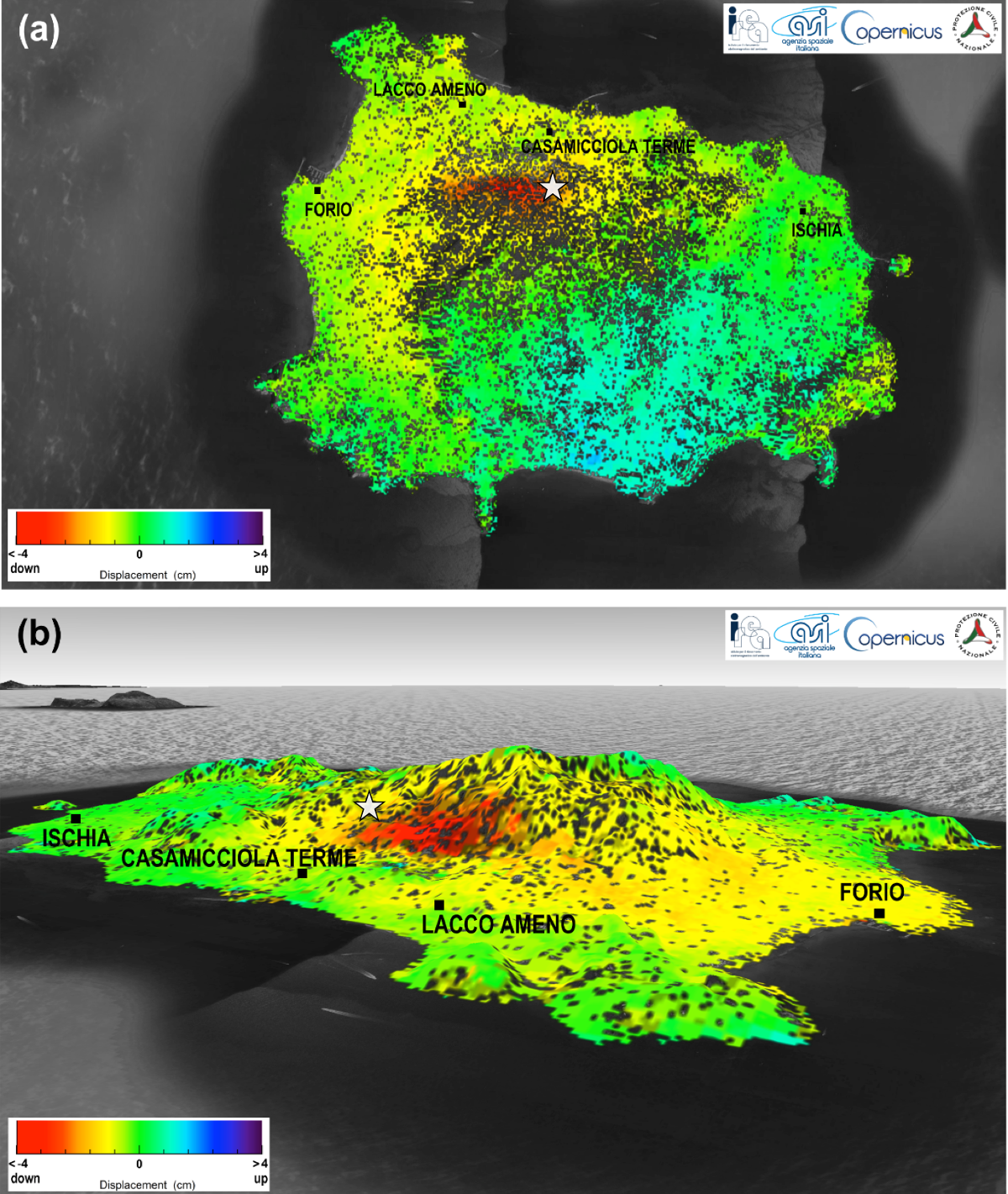
By jointly exploiting the ascending (i.e., the satellite flew from South to North) and descending (the satellite flew from North to South) displacement maps shown in Figure 1, CNR-IREA researchers computed the Vertical component of the ground displacements. Such a map is presented in Figure 2, in both a planar and 3D views. In particular, it was detected a subsidence up to 4 centimetres in a region (in red) close to Casamicciola Terme, the area most affected by building damages.
Such results have been shared with the Istituto Nazionale di Geofisica e Vulcanologia (INGV), in a framework of fruitful cooperation. Moreover, detected displacements are consistent with the earthquake location of INGV (updated on 25 August 2017).
Figure 2 – Vertical component of the ground displacements computed from the maps of Figure 1: a) planar view; b) 3D view. The white star indicates the location of the epicentre according to INGV (updated on 25 August 2017). Contains modified Copernicus data (© 2017). CSK data are copyright of ASI (2017).
To obtain a synoptic picture of the ground displacements induced by an earthquake close to the epicentre area in very short time represents one of the objectives of the Italian DPC during a seismic crisis. The obtained results came out after a long cooperation between the DPC and their Centre of Competences – in this specific case CNR-IREA and ASI. On the basis of their expertise, such Competence Centres support the DPC in the use of satellite data and related value added information, as well as in their integration with the in situ data provided by others Competence Centres. This activity allowed developing products, methods and procedures that improved the capabilities of the National Service of the Civil Protection during emergency phases.


