Evaluation of bio-geophysical parameters using physically based models

fig

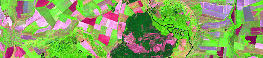
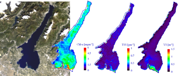
Some bio-geophysical parameters, such as qualitative or quantitative indicators of the condition of natural surfaces, can be estimated from remote sensed data. Images acquired from both optical and microwave spectrum range can be used as source of data, and different kind of physically based models can be implemented in order to estimate the parameters of interest. These models describe both the interaction between the electro-magnetic radiation and natural surfaces (e.g. radiative transfer models) and processes concerning surface properties (e.g. wave phenomena). When optical remote sensing techniques are used, data acquired in the visible-infrared wavelengths are analyzed taking in account absorption and scattering phenomena acting both in the atmospheric medium and at surface level. Thanks to radiative transfer equations, optical parameters, which in turn describe some bio-geophysical properties of natural surfaces, are estimated with good accuracy. On the other hand, microwave radiation properties make the Synthetic Aperture Radar (SAR) sensors particularly suitable to estimate geometric features of natural surfaces.

Nowadays, activities aimed to the determination of bio-geophysical parameters are many, with applications interesting different environments. At the basis of the estimation techniques, the signal recorded by satellite sensors is converted in physical quantities at surface level (e.g. spectral reflectance, radar cross section), which in turn can be related to different parameters. Among them: water quality parameter concentrations (e.g. chlorophyll-a, suspended solids); bottom depth and substrate characteristics in coastal zones; biomass estimation of both aquatic and terrestrial vegetation; evaluation of structural indicators of vegetation (e.g. Leaf Area Index); determination of snow cover properties (albedo, grain-size); estimation of wind field and directional properties of waves on the water surface; estimation of marine ice thickness at the interface with the open ocean.

Physically based models for the estimation of bio-geophysical parameters, if well calibrated and validated, allow the elaboration of remote images independently from instrumental and sensor characteristics, making this methodology especially suitable for retrospective and multi-temporal analysis using multi-sensor data. 


Additional Info

Nutritional status of crops
Monitoring of wetland ecosystems
Seasonal dynamics of alpine vegetation
Snow water content

Bresciani M., Stroppiana D., Odermatt D., Morabito G., Giardino C., 2011, Assessing remotely sensed chlorophyll-a for the implementation of the Water Framework Directive in European perialpine lakes, Science of the Total Environment, 409, pp. 3083-3091

Giardino C., Bresciani M., Pilkaityte R., Bartoli M., Razinkovas A., 2010, In situ measurements and satellite remote sensing of case 2 waters: first results from the Curonian Lagoon, Oceanologia, Vol. 52, 197-210.

Giardino C., Bresciani M., Villa P., Martinelli A., 2010, Application of remote sensing in water resource management: the case study of Lake Trasimeno, Italy. Water Resource Management, 24, 3885-3899.

Giardino C., Oggioni A., Bresciani M., Yan H., 2010, Remote sensing of suspended particulate matter in Himalayan lakes: a case-study of alpine lakes in the Mount Everest region. Mountain Research and Development, 30, 157-168.

Odermatt D., Giardino C, Heege T., 2010, Chlorophyll retrieval with MERIS Case-2-Regional in perialpine lakes, Remote Sensing of Environment, 114, 607-617.

Guanter L., Ruiz-Verdù A., Odermatt D., Giardino C., Simis S., Estellès V., Heege T., Domìnguez-Gòmez J. A., Moreno J., 2010, Atmospheric correction of ENVISAT/MERIS data over inland waters: Validation for European lakes, Remote Sensing of Environment, 114, 467-480.

Per altre pubblicazioni si rimanda ai CV delle persone coinvolte nella ricerca e alla voce "Prodotti della Ricerca"

    International
    2010-11: cyan-IS-was- CYanobacteria AssessmeNt in Italian and Swedish WAters from Space. (Bilateral agreement Italy-Sweden, MIUR)
    2010-12: EULAKES-European Lakes Under Environmental Stressors (EU Central Europe Programme)
    2009-11: LakeWatch-Lake WATer CHaracterisation with optical remote sensing (AO ISRO-ASI)
    2003-on going: MELINOS-Monitoring European Lakes by means of an Integrated Earth Observation System (ESA-AO ID553)
    2008: Remote sensing of Lake Chaohu (China): a feasibility study (Progetti e Ambiente S.p.A)
    2008-09: Implementation of the China component in partnership with IGSNRR (Activity 4.4.2) (HKKH, CAS Evk2-CNR)
    2007: Remote sensing of inland water quality: a focus on Chinese rivers (Telespazio, CNR-ISMAR).
    2004-06: Earth Observation for adaptive management of inland and coastal waters (CNR/CSIRO Agreement)
    2002-04: An Integrated Remote Sensing System Experiment for Lake Water (ASI)
    2001-02: HySens Darfem DAIS and ROSIS for Forest Ecosystems Monitoring (EC-FP5)
    2000-01: HySens Rosis for Algal Mapping in Lacustrine Environments (EC-FP5)
    1996-99: Salmon-Satellite Remote Sensing for Lake Monitoring (EC-FP4)
    Nazionali
    2011-14: CLAM PHYM-Coasts and Lake Assessment and Monitoring by PRISMA HYperspectral Mission (ASI)
    2010-11: Detection and mapping submerged vegetation in coastal zones (ISPRA-Istituto Superiore per la Protezione e la Ricerca Ambientale)
    2009-10: CARE-Change Analysis of River and wetland Ecological functionality (Provincia di Mantova)
    2008-10: RESTO-REmote Sensing for Trasimeno lake Observatory (Environmental Protection Agency of Umbria Region)
    2007-on going: Convenzione Canneti (CRA e Stazione Sperimentale E.Z. Sirmione)
    2005-07: Rizoma-Alla ricerca di ancoraggi per far germogliare la responsabilità ambientale (Fondazione Cariplo)
    2004-05: Il telerilevamento per il monitoraggio dei sistemi lacustri (Regione Lombardia)
    2004-05: L'utilizzo dei dati satellitari per il monitoraggio della qualità delle acque dei laghi Albano e Nemi (IIS)
    2003: Contributo del Telerilevamento satellitare per la mappatura della distribuzione del particellato sospeso nel Lago Maggiore (CNR-ISE)

    CNR-ISMAR, CNR-ISE
    Università Milano Bicocca - DISAT
    Università degli Studi di Parma - Dip.to Scienze Ambientali
    Università degli Studi di Milano - Facoltà di Agraria
    Università Cattolica del Sacro Cuore di Piacenza - Facoltà di Agraria
    CRA- Sirmione
    CSIRO Land and Water
    Klaipėda University - CORPI
    Stockholm University - Department of Systems Ecology

    Stazione Sperimentale Eugenio Zilioli a Sirmione
    Spettroradiometro FieldSpec Analytical Spectral Device Inc. Full Resolution Pro spectroradiometer (from 350 to 2500 nm)
    Spettroradiometro PhotoResearch SpectraScan PR-650 spectroradiometer (from 380 to 780 nm)
    Radiometro Exotech 100 BK radiometer (TM1, TM2, TM3 and TM4 filters)
    Fotometro solare EKO MS-120 (368 nm, 500 nm, 675 nm and 778 nm)
    Sensore PAR LI-192SA Underwater Quantum Sensor (Photosynthetically Active Radiation 400-700 nm)
    Termoradiometro Raytek PM40 (8-14 um)
    Ceptometro AccuPAR LP80 (Decagon Devices Inc.)
    Fluorescence And Turbidity Analiyzer (Turner Design-SCUFA fluorometer/turbidimeter and thermocouple coupled with hydrodinamic system to acquire spatial profiles in water bodies, syncronously to GPS, temperature and PAR measurements)
    Cyclops (Flurimetro ad immersione per determinazione di cianobatteri)
    Goniometro-MultiANgular Device for Radiometric Observations over Natural Surfaces
    Camera emisferica (Nikon Coolpix fisheye)